Data is the heart of your organisation. Without data and the intelligence it can bring, how do you effectively provide services?

But ask the question, how do we tap into that information to help us tackle issues facing local authorities, answer questions that are posed of providing current services, and plan for the future?
What are keys to begin to open the doors, so that you can start to realise the power and potential in the data you collect and hold?
As with many topics, the potential threads, thoughts, and methods are numerous and far reaching. The “what” and “how” are endless. So we will concentrate of a few key things as seeds to the wider aspects.
- UPRN and USRN as golden threads
- Challenges
- Key guidelines:
- Factors in low level integration
- How is GeoPlace helping
1. The UPRN (Unique Property Reference Number) and the USRN (Unique Street Reference Number) are the golden thread.

The UPRN and the USRN are the golden threads which enable address and street data to be easily referenced against each other, linking information held across different systems.
The power of these unique identifiers can connect and leverage data and intelligence held by other organisations, departments, and services. The data collected can be linked by the address or street elements only, meaning this can alleviate GDPR concerns and avoid straying into concerns of personal data. Data sharing therefore can be built to only allow the transfer of relevant data between systems. The identifiers can help drive better services, better intelligence, and bring in returns on investments.
GeoPlace sits at the heart of the interface between the local authorities who create and maintain Address and Street data. This is done primarily via the great work of Street Naming & Numbering Officers and Address and Street Custodians. GeoPlace validates and collates this data into a national resource which is then made available by Ordnance Survey through to end users via a myriad of data products made available to both the public and private Sectors.
The GeoPlace website contains many inspirational case studies together with insightful talks from our annual conferences on the connecting and use of different datasets that can demonstrate the power of the UPRN and USRN. These case studies demonstrate how the data can provide analysis and insights to plan and improve services, help find missing revenues for council tax and business rates for example amongst a number of benefits at local authority level.
However, these are only possible through the integration of UPRN or USRN into the different software systems, as these can facilitate the link between the datasets which open up and allow intelligence between them.
2. What are the challenges being faced?

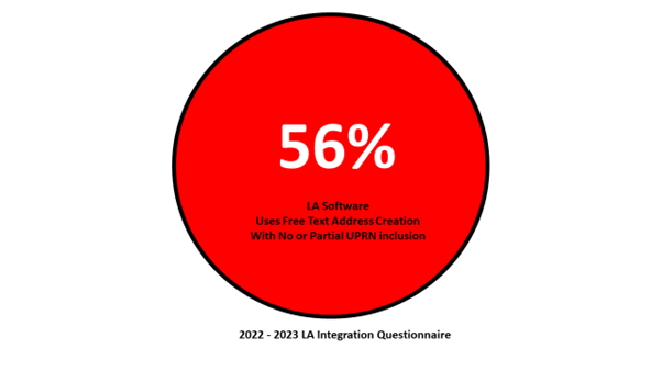
From our engagement with local authorities, we know that 56% of the software being used in local authorities do not fully mandate the use of the UPRN. This means the software either does not use the UPRN, or partially uses it but allows the inclusion of free text addresses which reduces the integrity of the address data.
So what????
The answer is simple. Where the software does not cater for the UPRN, this makes data linking, address verification and realising the data across different datasets difficult. Equally where it does partially allow for this, it requires sustained maintenance and effort to ensure those freely entered addresses are subsequently matched and merged with its assigned UPRN and official address. The potential benefits are made harder or diminished without the UPRN golden thread being used effectively.
3. What are the key guidelines to help realise the potential of data using the UPRN and USRN as the golden threads?
The following 4 software themes (Consume, Update, Expose, Export), derived from engagement with local authorities, have been deemed as being the key enabling areas which can help authorities effectively create, maintain, use, and link address and street data across their organisation.

3.1. Consume the data
Key guideline: Be able to consume the UPRN / USRN into the software in multiple formats.
Why:
- By being able to consume the UPRN/USRN into the software in multiple formats it allows for data to be linked via these key markers in different systems.
- This opens sharing the intelligence across different datasets, also being able to analyse data between datasets.
- It can lead to improved services, cost savings, and identifying revenue potential.
Key guideline: Be able to generate load reports when data is loaded to check for any issues in the process.
Why:
When importing and updating any data it is important that quality checks are in place.
- These include the ability to generate reports of what is updated, how it is updated, and the success of any changes made have been.
- Without a reporting process for example, importing a file with 250 new addresses, there may be an assumption that this has completed successfully. But it may have had several issues with the data partly loading or creating duplicate records.
- Without a load report this may not be detected until too late causing issues and a loss of data integrity.

3.2. Update the data
Key guideline: Be able to be updated frequently. This will depend on the frequency of the data refresh needed for each service.
Why:
- Being able to update the data at the most frequent rate means the data itself has better currency. This allows for better intelligence sharing and analysis potential between systems.

3.3. Expose the data
Key guideline: Be able to display the UPRN or USRN in the software.
Why:
- The Unique Property Reference Number (UPRN) and Unique Street Reference Number (USRN) are recognised identifiers for every addressable location and street across England and Wales.
- These data identifiers are being accepted and used across an increasing range of sectors and applications.
- Being able to easily see and quote them within the software makes having discussions on all aspects of addresses and streets easier.
Key guideline: Be able to search by UPRN or USRN.
Why:
- As these are unique identifiers (and unambiguous), the ability to search ensures that results are more accurate.
- Free text searches on quoted address can be misquoted or typed leading to inaccurate results. Postcode searches show a delivery area as opposed to a unique location.
Key guideline: Can correctly construct the address.
Why:
- The software should be able to hold and construct an address correctly based on the different and recognised component parts.
- Local authority Address and Street Custodians create and maintain this data based on recognised formats and rules, and the software should be able to cater for this.
- GeoPlace publish a set of guidelines known as the Data Transfer Format for consuming and exporting data alongside a Data Entry Conventions of the construction of the address and street data.
Key guideline: Be able to able filter data through different criteria based on the address format.
Why:
- Filters should be available in the software to allow the data to filtered based on a variety of criteria, such as the street, property name or number, postal codes for example.

3.4. Export the data
Key guideline: Be able to export the data and include the UPRN or USRN so that it can be loaded into different systems and be used for matching and analysis.
Why:
- As the software should be able to consume and export the address and street data including the UPRN and USRN in the correct format, it should also be able to export the same data using the same rules.
4. Two Key Factors contributing to a low level of integration of the UPRN and USRN
Through engagement with the local authorities, it is evident that there are two keys factors acting as barriers to integration of the UPRN into key software systems.
These are how the procurement of new software is being managed, and a wider issue of how the UPRN and USRN are being integrated across other software and systems within the local authority.
How these important data keys (UPRN and USRN), as well as ensuring address data in these systems are included and managed are important to connecting datasets and realising the data intelligence held within them.

With the procurement of software, it is about ensuring that these can consume and retain the UPRN or USRN. This will allow the connecting of other datasets using these and releasing the data intelligence in these datasets. Think of the UPRN and USRN as the golden thread that enables addresses to be easily referenced against each other, linking information held in one system to another.
With the procurement of software, the low level of integration of the UPRN and USRN can be because:
- Ineffective procurement processes
- Assumption that the software will allow the UPRN or USRN to be consumed, updated, exposed, and exported.
- Assumption that the key features enabling the UPRN to be consumed,
updated, exposed, and exported come as standard. Therefore, they are not
explicitly specified as essential and considered as optional. - There can be no or little testing before purchase of the software.
- Issues with the integration with other systems
- Software could not consume, hold, update and export the UPRN or USRN. Either as the procured solution or did not have the functionality within other software that were being linked to.
- No integration roadmap
- No analysis or plan to determine where they are now, where they want to be and tying up with corporate strategies (such as IT) had been produced.
- Issues fixing data consumption & integration issues
- The lack of functionality being fixed by additional consultancy, building manual solutions, or finding additional software solutions. All costing additional funding and resources and putting tensions on the customer to supplier relationships.
5. How is GeoPlace helping?
Through wider engagement, GeoPlace has developed advice and tools to help bridge the gaps for the issues identified:
Procurement criteria generator
GeoPlace has created a procurement statement generator for local authorities which generates key functionality statements for the tender process for all systems. This provides the address handling requirements up front and allows suppliers to be clear on what they can deliver.
Address and Street GMS Procurement Criteria Suggestions
GeoPlace have also developed through the engagement of the Address and Street Custodians a set of criteria of requirements and specifications specifically for gazetteer management systems. These are designed to help authorities build into their tendering of these systems better up-front requirements.


