By Catherine Wood, Spatial Data Analyst.


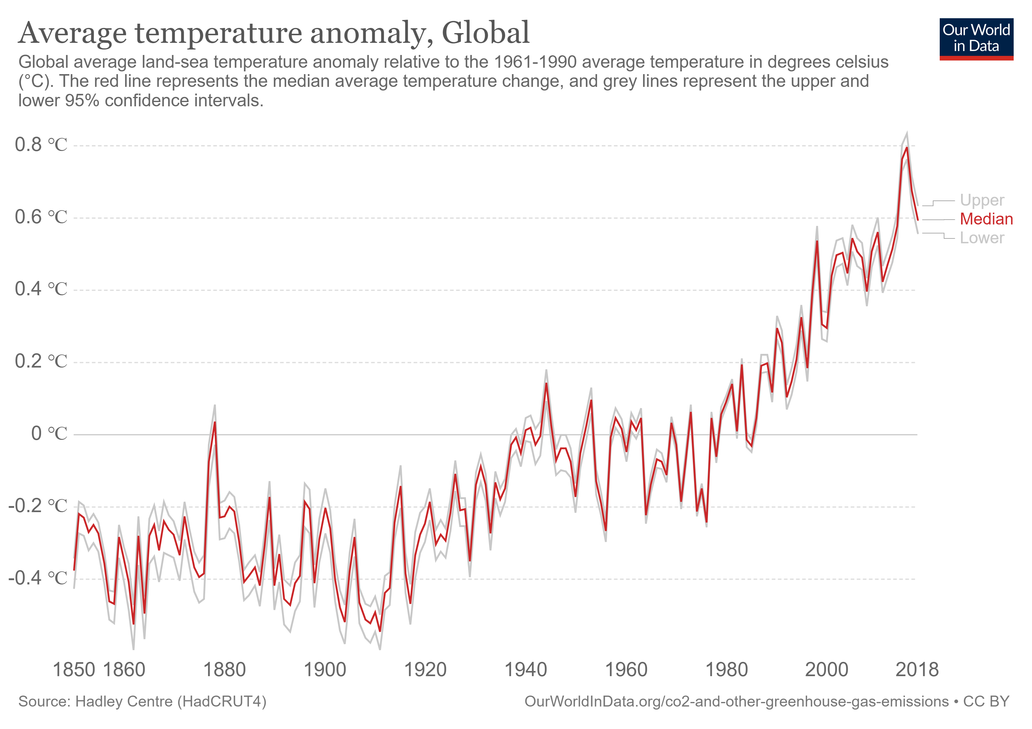
The Earth is warming ten times faster than ever before and so the UK has made a commitment to reach net-zero greenhouse gas emissions (GHGs) by 2050. Although temporal data has traditionally been used to indicate changes in climate, spatial data is increasingly being used to highlight where those changes occur. With both temporal and geospatial data being used in conjunction with one another, we are able to paint a clearer picture of our impact on the Earth.

(Interactive chart available at: https://ourworldindata.org/grapher/co-emissions-per-capita)
The National Geospatial Strategy - Sir Andrew Dilnot
The National Geospatial Strategy is currently under development, and aims to promote the use of geospatial data in the relevant sectors. It could be argued that variation is why we need tangible data; we can then identify, measure and report changes. Therefore, the use of geospatial data is being greatly encouraged, with some organisations already innovating within the space.
One example is the National Underground Assets Register, which will merge the existing data on the subsurface infrastructure to produce a nation wide dataset detailing the types of assets and their depths etc. This will reduce accidents, disruption and wasted resources, all of which will help towards reducing our impact of the environment.
Another scheme applying geospatial data is COMMUNITREE. This project is collecting tree data from across the UK and has developed the app Treezilla, an open source map detailing the locations and types of trees. By creating this we can begin to understand the benefits the trees are having, and can thus plant more strategically to ensure the best environmental outcome.
The Committee on Climate Change - Dr Rebecca Heaton
Historically, the UK has been the largest emitter of CO2 and so it could be argued that we have a moral responsibility to reduce our GHG emissions more than anywhere else on the globe. To do this, the Committee on Climate Change (the CCC) was established as part of the Climate Change Act 2008.
The CCC has created a strategy to reduce the UK's contribution to global warming. The overall target for the UK is a 100% reduction in GHGs from 1990, covering all sectors of the economy. As Wales has less opportunity for CO2 storage and relatively high agricultural emissions, their target is a 95% reduction in emissions by 2050 relative to 1990. Conversely, Scotland has greater potential for emissions removal and so are adopting a more ambitious target; aiming for net-zero emissions by 2045.

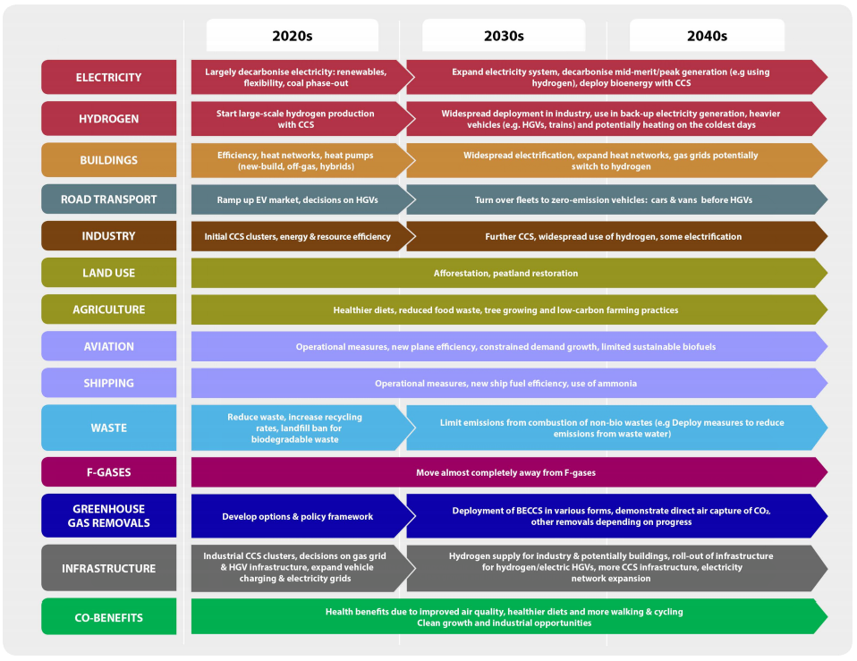
Abbreviations: CCS = carbon capture and storage. EV = electric vehicle. BECCS = bioenergy with CCS.
Image source: Committee on Climate Change analysis. 'NetZero - The UK's contribution to stopping global warming'.
The net-zero challenge will focus on multiple pathways within all different sectors to reduce GHG emissions. Some examples include decarbonising electricity through the use of renewable energy sources, reducing waste through increased recycling, and improving infrastructure to support and encourage the use of electric vehicles.
The cost of these targets is relatively small, with many of the changes requiring no or only limited additional costs. The benefits however, will be significant. We'll have improved quality of life, lower risks from climate change, and even industrial opportunities.
All of these pathways aim to limit global warming to 1.5°C, which although doesn't sound like much, anything over this is predicted to have irreversible and catastrophic effects.
With this strategy, the UK are aiming to lead by example and hopefully other governments will follow, as action needs to take place now.
Strava Metro - Tom Knights
Strava is an activity tracking platform; a social network of exercise. With 40+ million members, it is the world's largest active transportation dataset, meaning there is a plethora of insights to be gained. Strava Metro aims to utilise these insights to help authorities improve pedestrian and cycling infrastructure.
More of us are using physical activity as a commuting method, it's cheaper and a great way to incorporate exercise into our daily lives. The environmental impact is significant too; commuting by cycling, running and walking has offset 102,105 trillion lbs of CO2 (remembering that this is only using recorded data, meaning the number is likely to be much greater!).
The safer the routes are, the more likely people are going to choose to run/cycle/walk as a travelling method. An example of this correlation was demonstrated with the Cykelslangen (Bicycle Snake) in Copenhagen. After the Cykelslangen was built, there was a 78% increase in trips per month.
Strava Metro highlights perfectly how geospatial data can be used to reduce our impact on the environment, and how geospatial data is already intertwined with our everyday lives.
Fun Fact!1 in 7 people in the UK are Strava users, which is around 9.5 million! Why not use this heatmap to see activity routes in your area?
Qualis Flow - Brittany Harris
Sustainability pays. A large aspect of sustainability is around reducing wasted resources, which we're all aware can cost a lot. Qualis Flow uses AI to improve the efficiency of construction sites. Through the automatic tracking of work tickets, they are able to easily locate materials for sites and reduce hours spent manually inputting the tickets. At one site, 36,000 kg of CO2 was saved just to track the timber.
Construction companies need to take a sustainable approach not only to reduce their impact on the environment, but because it is a more cost-effective method.
When sustainability is at the forefront of a company's ethos, there will be increased efficiency, which will lead to increased productivity and thus reduce overall costs. Data is integral for these insights, and integral for creating a more sustainable way of life.
Transport Research Laboratory (TRL) - Paul Campion
TRL is an independent company that helps organisations create transport systems that are: safe, clean, affordable, livable and efficient.
One of the ideas they are working on is to producing a national Digital Twin, which aims to replicate the entire built environment. In doing so, they can test different scenarios for features and the one that works best can be replicated in the real world. Having this test environment could revolutionise how the transport network is maintained and developed. This will likely have a huge impact on our journeys, making them more efficient, sustainable and hopefully more enjoyable!
[youtube
A Planet of 3 Billion - Dr Christopher Tucker
The words on everybody's lips is 'Climate Emergency' or 'Climate Crisis', but there is another environmental aspect that is almost being completely ignored; our population. Over the last 200 years the Earth's population has exploded and we are currently at around 7.7 billion. Thankfully, the global population growth rate peaked long ago (1963), but this does not mean the current population isn't having adverse affects.

Every ecosystem has a carrying capacity, which is the number of people, animals, or crops which a region can support without environmental degradation. It has been estimated, that the Earth's absolute maximum carrying capacity is estimated to be just below 10 billion and, according to the UN, we're en route to a population of 9.7 billion in 2050. However, Dr Tucker argues that a sustainable population is considerably less than this, even considerably less than the current population. He estimates that 3 billion is actually the maximum number for us to live sustainably. Not only is the population growing, we are each able to consume more things and equally generate more waste, it's a lot more complicated than a increasing number.
What are some of the effects of our growing population?
- Food shortage
- Water shortage
- Air, water and land pollution
- Rising inflation.
While these statistics are all alarming, Dr Tucker argues that is feasible for us to reduce our population down to a more manageable 3 billion, even without a second Black Death. This would involve rewilding and deindustrialisation, the implementation of ecological debt, and the increased empowerment of women.
Overall, the conference was equal parts fascinating and terrifying; but there is still hope. Geospatial data is being used to mould our approach to reducing our impact on the Earth and it was encouraging to see that action is being taken.
Tips and interesting sites
Tips to reduce your own carbon footprint:
The way you travel
- Choose to walk and cycle or take public transport in preference to a car
- Make your next car an electric one, and then charge it 'smartly'
- Minimise flying, especially long-haul, where possible.
In your home
- Improve the energy efficiency of your home (or ask your landlord to) through draught proofing, improved insulation, choosing LED light-bulbs and appliances with high efficiency ratings
- Set thermostats no higher than 19°C and the water temperature in heating systems no higher than 55°C
- Consider switching to a low-carbon heating system such as a heat pump, especially if you live off the gas grid; if you are on the gas grid consider a hybrid system.
What you eat and buy
- Eat a healthy diet, for example with less beef, lamb and dairy
- Eliminate food waste as far as possible and make sure that you use separate food waste collections if available. Reduce, reuse and recycle your other waste too
- Use only peat-free compost
- Choose good quality products that will last, use them for longer and try to repair before you replace
- Share rather than buy items like power tools that you don't use frequently. If you don't/won't use your car regularly then consider joining a car club instead.
Look for changes that you can make in your workplace or school to reduce emissions and support your colleagues to make changes too
Talk about your experiences and help to raise awareness of the need to act. Consider the wider impacts of your actions (e.g. through your pension or ISA and via the companies you buy from).
ourworldindata - visualisations for all aspects of the world
theworldcounts - current statistics across the globe.
What are your thoughts on the climate crisis and how geospatial data can help?
Please add your comments to the page as discussion is one of the foundations of innovation.


