We see an ever-increasing range of uses in local authorities where UPRNs and USRNs simplify processes, from school admissions to planning applications. Convincing decision makers needs a solid business case showing that improved processes will produce a good return on investment.
This report produced by ConsultingWhere on behalf of GeoPlace, with help from many local authority address and street Custodians, demonstrates that local authorities in England and Wales have realised increased revenue and cost savings of an estimated £250 million over the last 5 years.
Over the next 5 years, through further integration into council systems, it will yield a 6:1 return. In simple terms this means that for every £1 invested local authorities can expect to realise £6 in cost efficiencies and increased revenue
As the study only evaluated a subset of use cases this figure is likely to be exceeded if all applications were quantified and social benefits quantified.
Video
Achieving best value
An overview of the research, how we went about it and what we found.

Key findings
Many different local authority functions rely on address and street data. It’s a vital part of the references used to enable or deliver services, and therefore needs to be current, consistent, and comprehensive.
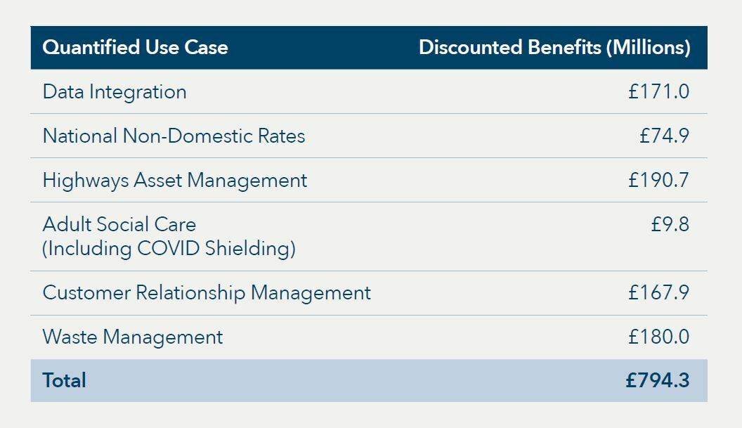
The study focussed on the following use cases
- Data Integration
- Non-Domestic Rates
- Highways Asset Management
- Adult Social Care
- Customer Relationship Management
- Waste management
The study showed that many authorities have been using address and street data effectively to create innovative services – improving efficiency within the authority, aiding revenue collection, and offering better customer service.
This table summarises the use cases in financial terms
Download
Read the summary report
Download the summary of the cost benefit analysis here.
Title
Cost-Benefit-Summary.pdf
Size
163.50 KB
Uploaded
27 June 2022
Title
ROIReport2022.pdf
Size
4.63 MB
Uploaded
10 May 2022
Improving your authority’s ROI
GeoPlace and the LGA have put together a 3-step process to help local authorities discover their ROI:
- Talk to your local address/street Custodian. The LGA’s ‘Find my local address and street Custodian’ tool shows who your Custodian is
- Discover which parts of your authority could start deriving these benefits:
- Get your free integration report from GeoPlace (updated version ready on 1st November 2022)
- On a technical level, use GeoPlace’s free UPRN integration tool to see when from more-effective use of location data could help you
- Ensure your procurement of new systems supports UPRN integration by using GeoPlace’s new tool for the commissioning and purchase of new local authority systems’ software.
Find out more about using UPRNs and USRNs to integrate data in your authority.
Additionally, we welcome direct enquiries from local authority teams or data professionals who’d like to learn more, free of charge, about realising the benefits of 6:1 investment. Contact GeoPlace for more information.
ROI analysis
Get a personalised ROI analysis
GeoPlace offers a cost-effective Return on Investment service to individual local authorities, to prove the benefits of address and streets gazetteers

Getting value from UPRNs
The LGA believes that UPRNs are key to almost everything that’s delivered or achieved by councils.
Everything that local government does happens somewhere, be it housing a homeless person, collecting someone's bin or providing support to a family in difficulty. Precise location information is essential for councils to deliver services to the residents they serve. Using UPRNs enables disparate data sets and innovative applications of data to be blended to provide insight and understanding about residents and businesses, which is needed to deliver area-based services effectively on the ground.
Adding UPRNs and USRNs to records can provide quick, easy wins. For example, with the UPRN in place, it is easier to confirm that a more vulnerable family receiving social care is also benefiting from the right council tax benefits, or that commercial buildings are paying the right amount of business rates.
Video
Easy wins for local authorities
In this video, Juliet Whitworth, Research and Information Manager at the LGA, explains that there are 'easy wins' for local authorities with UPRNs.
The jigsaw problem
With their responsibility for front-line service delivery, councils have access to a huge amount of information. What if there was a way of bringing this information together so that it can be analysed to provide more effective services? To save officer time in front and back office processes? To understand fraud and error? To provide insight into social problems? Here are nine case studies with the answer.

More about the Local Land and Property Gazetteer and Local Street Gazetteer
Just about every local authority service relates to an address or a street. Having access to an updated and maintained central address and street database that every department in the council uses will provide financial and service benefits for residents.
Every local authority has a corporate resource, its Local Land and Property Gazetteer (LLPG) and/or Local Street Gazetteer (LSG) and a Custodian who manages all change intelligence. Change intelligence includes things such as:
- new developments
- when a property moves from planning to being lived in
- splits and merges or changes in the status of a property, such as changing from commercial to residential.
By ensuring that this is recorded in one place and shared on a corporate basis, relevant departments such as council tax, NDR, electoral roll and environmental services can access the information they need, when they need it and ensure that residents are provided with the best possible service.
Each local authority is responsible for creating and maintaining a complete and granular set of all addressable locations in their area. That responsibility to name and number properties and streets is defined in legislation. Street names and property addresses are created as new properties or changes to the built environment take place as part of their planning and development processes.
The LSG is used for a variety of services within local authorities, not only to underpin street works but as the core dataset in activities that use street data. This makes the LSG a key strategic data source within local authority internal management systems. LSGs are created and maintained under statute and are compiled at a national hub, managed by GeoPlace to create the NSG. All 174 highway authorities across England and Wales upload their LSG data to the NSG hub, where the information is then verified and made available to licenced users via web downloads.
Find out more about your Local Land and Property Gazetteer: Create. Maintain. Use. Your LLPG.
Find out more about your Local Street Gazetteer: Create. Maintain. Use. Your LSG.
Data in use
UPRNs delivering health and social care
The scale and rapid response required by public sector bodies in response to the COVID-19 pandemic was unprecedented in recent times. The value of data about place has been vital to accurately provide efficient & effective service delivery solutions.

Value of data
Briefing your local councillors
See our briefing aimed at local councillors on why they should be interested in Address and Street data.

Local authority resources
Find out more about location intelligence
This series of videos explains the value of address and street data for senior decision-makers who want to find extra value or deliver more benefits to their customers. Published by Socitm with sponsorship from GeoPlace and support from the LGA.
